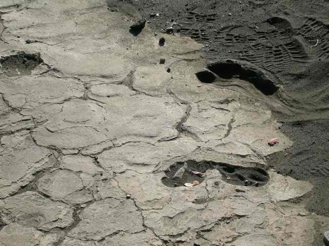
 The 1790 Footprints refer to a collection of footprints, believed to be imprints of ancient Hawaiians, found near the Kīlauea Volcano in the Hawaii Volcanoes National Park on the island of Hawaii. The footprints come in variety of sizes making experts believe that they were made by men, women, children and even animals. The prints also indicate diffent actions including walking and running.
Cast in a cement-like layer of volcanic ash, which is believed to date back to the 1790 explosive eruption of Kilauea volcano, the prints are assumed to have been left by the warriors and their household who served during chief Keoua Kuahu'ula's reign. According to folk lore, the chief and his company crossed the summit area of the volcano during the eruption enroute to battle with warriors of Kamehameha the Great.
The footprints were accidentally discovered by geologist Ruy H. Finch in the hardened ash of the Kaū Desert while investigating a 1919 eruption that created Mauna Iki (small mountain). Although the National Park had been formed by then, these lands were owned by the Territory of Hawaii. In 1938 the area was proposed as a bombing practice range, resulting in protest from conservation groups. On June 20, 1938 the Federal Government bought the land to add to the park, with the bombing range limited to four and a half square miles. The Army never used the land, but the Navy caused some injuries to fishermen in 1945. In June 1950 the bombing range was returned to the park after being cleared of unexploded ordnance.
The site was listed in the National Register of Historic Places on August 7, 1974 as site number 74000351. It can be accessed via the Kau Desert Trailhead adjacent to Highway 11 or via the Kau Desert Trail from Crater Rim Drive.
Ash deposits in this area are fragile and can be easily broken, hence, visitors are requested to remain on the established trail and also to respect the cultural and natural resources of the area. It is prohibited to move rocks or remove plants as alteration of the landscape may result in the destruction of a sensitive resource.
These trails or roads might be closed during high levels of volcanic activity; check conditions in advance.

